
Plan and rediscover exotic Andaman with incredible experiences all specially made for you.
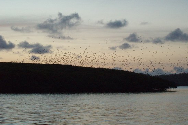
Baratang is an Island situated in Middle Andaman zone of Great Andaman. It is around 65 kilometers by road “Andaman Trunk Road” Andaman Trunk Road to Rangat and Diglipur passes through this island) from Port Blair. This island between South and Middle Andaman has beautiful beaches, mangrove creeks, mud-volcanoes and limestone caves. Baratang is an Island situated in Middle Andaman zone of Great Andaman. It is around 65 kilometers by road from Port Blair. As per 2001 census Baratang has population of 6500. The population consists people of Ranchi community, Bengalis, Telugus, Tamil and Malayalam. Baratang was a non-existent entity on the tourist map before the mud volcano and Limestone caves were opened for tourists in 2002. An estimated 5000 tourists visit the place daily during seasons (Nov to March). A creative mangrove canopy walk connects to a trail through moist forests that leads to the lime stone caves. There are around 180 lime Stones in vicinity of each other, but only one is open for tourists as the rest are unsafe for entry. Located about 90 kilometers from the centre of the capital city of Port Blair, is one such peculiar tourist spot that can make tourists feel as if they have drifted away to some other region away from the Andaman. This place is about a 2 hours ride away from the city via bus and is well connected with the STS Bus terminus at the Port Blair city. This mysterious and intoxicating place is referred to the Limestone Caves of the Baratang Island within the Andaman and Nicobar Islands. These caves are a treat for those who are exhausted with the beaches, bathing and other water sports. They offer a whole new view and showcase a different aspect of the Andaman and Nicobar Islands. But there are some fun facts about the Limestone Caves that add to the attraction of the place, some of which are mentioned below: 1. The journey to the caves is more mesmerizing than the trip to any other island as the boat travels through the Tribal reserves of the Baratung island which is actually known for its rich tribal population 2. The sojourn becomes even more fun when travelers can spot sun-bathing sea crocodiles, when they are almost about to reach the caves. The crocodiles are found with their jaws wide open and sit still like stones to camouflage with their surroundings. 3. The Limestone Caves are surrounded by mangroves and offers all the delights of a mangrove forests except for tigers that are found more commonly in the other Mangrove forest of India, which is the Sunderbans 4. For the geography lovers, this is one of those rare caves that have both stalactites and stalagmites existing in the same cave unlike popularly known fact that these can’t coexist. 5. Another interesting fact about these caves is that he lime stone structures have been formed over ages and have not been traversed or exploited in anyway. It is one of those sites that have remained untouched by humans and have retained their form and structure since the beginning of its formation. Facts about Limestone cave” “Another view of the Limestone Caves”Although these lime stone formations are found primarily in caves at least on this island, there are several deposits of layers of limes forming stones, providing different shades to single massive rock. It is relatively longer travel to the limestone caves unlike the other short ferry rides to different islands from the capital city. The best way to reach there is to drive or take a bus from Port Blair via the Andaman Trunk Road, then take a short jetty from the Middle Strait to the Baratang Island followed by a half an hour ride on a speedboat to the region with the limestone caves and depositions. If you intend to explore a different and mysterious side of the Andaman then a trip to the Limestone caves is a must. A mud volcano is formed by emission of de-pressurized pore water and natural gases (mainly hydrocarbon gases like Methane) emitted by decaying organic matter underground. The gases at times are emitted with loud explosion and associated with fire flares. As the mud is pushed upwards by the gas, it deposits and hardens above the ground. As more mud oozes out and spills over the edge it grows in size, gradually forming a miniature volcano with rich, creamy mud crater at the top. More than 25 Mud volcano sites are discovered at Andaman Islands as early as 1954 and scattered between North and South Andaman. As per available information the first observed mud volcano explosion was observed in March 1983 in Nilambur Village in Baratang Island. Since 2003 both The sunset at the Parrot Island is a view to die for, since it not only reveals the horizon where the sea and sky meet marked with a crimson line Wonderful but uninhabited island, located to the southern end of the Andaman region, which ensures the variety of beach destinations on Indian soil, is the Parrot Island. This island is a part of the Baratang region, situated in the south of the Andaman Island and can be accessed from the Baratang Jetty. There are several things to be enjoyed at the Parrot Island which you must know of before traversing the barren terrains of the virgin Island. Special Things to see at the Parrot IslandEvery Island in Andaman has its own list of attractions apart from the pristine beaches and crystal clear waters, so does Parrot Island. Rather in case of this island, you can enjoy quite a few special views even on the way. To begin with the island has to be reached via a dinghy boat as there are no launch services available from the Baratang Jettyand then pass through a creek, which is a beautiful but spooky ride. While you are about to reach the island you can see a completely different range of Mangrove trees as these trees seem to be evenly cut, giving out the impression of a man-made Mangrove garden. For those you are wondering how is that possible? Well the answer comes from the reason behind the origin of the name of this Island. Every evening hundreds of parrots flock to the island and trim and prune the trees with their blood red beaks during their overnight stay. These parrots again depart the next morning, only to return to the island the next evening. Along with the green parrots, tourists can even see a large flock of parakeets, which are usually multi-colored and are one of the most beautiful birds to live on the face of this earth. The last, but not the least,marks the timing for the arrival of the beautiful parrots and parakeets.One of the most wonderful things observed by the local people, about the birds of this island, is that, at first only about 5 parrots fly over the island and depart, followed by a similar flock which seems to have come for an inspection which is finally followed by a hundreds of parrots and parakeets come to roost on the Mangrove branches.When you are on this island, it is advisable to either spend the night at the Forest and Government guest houses or leave while there is still enough natural illumination left, or else you may lose your way to the Baratang Jetty while traversing via the vast stretches of the Arabian Sea. But whatever may be the time of your departure, you must make a visit to this island, if you are fond of the wonders of nature and of course birds Rangat is a town on the Middle Andaman Island, Andaman Archipelago. It is also one of the three counties (tehsils) administrative divisions of the North and Middle Andaman district, in the Andaman and Nicobar Islandsunion territory of India. Rangat is 210 km from Port Blair and 70 km south of Mayabunder. The town is well connected by road and sea routes. Some nearby tourist attractions are Amkunj Beach (8 km away) DhaniNallah located at out skirts of Rangat and Cutbert Bay Beach (18 km away). The latter is an important turtle nesting ground, especially from December to February. Aamkunj beach is located at a distance of about 08 kms from Rangat towards Mayabunder and about one km. from the Nimbutala helipad. Amkunj Bay beach is another sandy beach on the way to Cutbert Bay. This beach, barely 100 mts from the main road i.e. ATR, is ideal for swimming, sun bathing and relaxation. This beach, developed in a unique way with the help of eco-friendly structures, has a couple of eco-huts and groves named after locally found flora (casurina, jamun, pandanus). The eco-friendly beach facilities such as log sofas, log tepoys, indeed novel and innovative ideas, provides a perfect place for recreation to the people of Rangat and the adjoining villages. Cutbert Bay Beach is located at a distance of 12 km. from Rangat. This lengthy beach with a tropical forest bordering is famous for turtle nesting in season. One can view the turtle nesting during December-February. Hawksbill Nest, a Guest House, run by the Tourism Department, near Cutbert Bay beach offers accommodation. The guest house is enroute to Mayabunder and Diglipur. Dhaninallah Mangrove Nature Walk is located at a distance of 20 Kms. from Rangat adjacent to ATR. It is a wooden boardwalk meandering through mangrove creek for a distance of 713 mtrs. It is the longest walkway of its kind in the whole country. This place Dhaninallah is named after a mangrove associate locally called as Dhanipatti. This Walkway leads to a very beautiful long beach called as Dhaninallah beach, which is known for turtle nesting. How to reach: Entry to Dhaninallah mangrove walkway is from the ATR at Betapur and is about 20 kms from Rangat towards Mayabunder. This boardwalk is completely an eco-friendly structure constructed departmentally using rejected teak logs. This walkway provides an unique opportunity to witness diverse mangrove eco-system found in Andaman in a single place. This long board walk has halt at intervals, for the visitors to sit & enjoy the gift of nature from close quarters. These halts are named after the commonly found birds of this locality for generating awareness on wildlife. An eco-hut at the midway of the boardwalk is named after the most frequented sea turtle of the Dhaninallah beach (the beach to which this walkway leads to) i.e. Olive Ridley. This is an ideal location for nature awareness camps. The walkway leads to a beautiful and long beach known as Dhaninallah beach. One can see a hatchery for sea turtles, maintained by the Wildlife Officials as an conservation effort. A nature trail from the Walkway leads to the eco-friendly beach facilities which include a tree top hut, a couple of eco-huts, sit-out areas, changing rooms and toilet facilities. One can have a fantastic view of the Cutbert Bay Wildlife Sanctuary from the tree top hut. The beach has been adequately furnished with eco-friendly log sofas and log teapoys for the convenience of the visitors Yerrata is located at a distance of 8 kms from Rangat along with luxuriant mangrove creeks. Yerrata is having a jetty from where ferry is operated to Long Island. Yerrata, which is well connected by road has breath-taking scenic beauty of various species of mangroves and is an ideal location to learn about diverse variety of mangroves. As a step towards creating awareness among general public about mangroves, department of Environment and Forests has established a Mangrove Interpretation Centre which has attractive display panels depicting various species of mangroves found in these islands. A mangrove view watchtower is an unique structure of its kind which provides an opportunity to have a panoramic view of mangroves and adjacent forest. This is the only such tower in whole of A & N Islands to view mangroves. The height of the watch tower is 13 mtrs. The Department of Environment and Forests has developed a Mangrove beach trail having 300 mtrs. stretch of bench walk passing through the natural mangrove forest which is an important tourist attraction. The bench-walk gives the visitors a fantastic feel of mangroves. Panchavati Hills has a beautiful, gentle waterfall. The agricultural farm en-route, housing a rich bank of vegetation, is of interest to botany enthusiasts. Long Island is an island of the Andaman Islands. It belongs to the North and Middle Andaman administrative district, part of the Indianunion territory of Andaman and Nicobar Islands.[6]the island is lying 80 km (50 mi) north from Port Blair. Long Island, just 47 nautical miles from Port Blair, having an area of about 18 sq.km., is a modern village with population of around 2000 having many plus points and facilities generally not available in other villages of Bay Islands. It has its own power-house, a well equipped Boat Building Yard, Senior Secondary School, bank, wireless facilities, hospital, Range Forest Office and even police outpost. Long Island is a dreamland settlement without any road network. Only four feet wide concrete footpath connects different parts of the ‘Panchayat’ area starting from the jetty. Casurina trees make pleasant avenue astride the footpath leading to Government School and to Police Outpost area. Islanders cover these footpath kilometers several times just to reach work place, school, Range Forest Office or temple. Vast marine wealth and exclusive beaches, cosy caves, green hills and magnificent mangroves – a perfect package for adventure tourism. The pristine beauty of Long Island and adjacent islands in the form of lush green tropical forests, untouched virgin beaches coupled with unique Marine ecosystem attracts the tourists from different parts of India and abroad. The Islands have dense tropical forests of all types ranging from Tidal Swamp forests to Evergreen Forests. It has beautiful virgin silvery beaches along its coasts at Lalaji Bay and Merk Bay of North Passage Island adjacent to Long Island. Cruising through the creek at Yerrata and the sunset view from Long Island can attract any nature lover to these places. Long Island is also a paradise for birding. Lalaji Bay Beach, in Long Island, Rangat falls in Middle Andaman. There are regular boats from Yerrata Jetty in Rangat to Long Island. One way ride takes about 1.5 hrs and goes through beautiful creek making it a memorable journey. Lalaji Bay beach is a beautiful, sandy beach on the west coast of Long Island. One has to take a boat from Rangat jetty to reach here. The boat ride is quite comfortable and takes around 1.5 hrs. The boat cruises through Mangrove creek thus providing equally scenic views around. From Long Island jetty, one has to take a fiber boat to get to the West coast and then walk a few kilometers to reach the beach. The island has a long, sprawling white sandy beach with clear water. One can easily bask in the sun or get immersed in the clean water to give a treat to mind and body. Lalaji Bay Beach” located in Long Island in Andaman and Nicobar can best be described as “an extremely scenic and pristine beach”. It is surrounded by an extremely beautiful and tranquil environment that includes a large number of coconut trees and crystal clear water. It is also considered to be a deserted beach and, hence ideal for those who want to relax in absolute isolation. Additionally, this beach is also perfectly suited for activities such as swimming and snorkelling. So if you intend to relax by completely secluding yourself from the world around you then, this beach is what you are looking for. The summer months in Long Island begins in April and ends in June with temperatures ranging from a minimum 25 degree Celsius to a maximum of 35 degree Celsius. The rainfall received during the monsoons which begins in July and ends in September ranges from moderate to heavy. Finally, winter begins in October and ends in March with, the climate being extremely pleasant and, temperatures ranging from a minimum of 20 degree Celsius to a maximum of 34 degree Celsius. So the ideal time to visit this beautiful beach in Long Island is from October to March as during this period the temperature is ideally suited for activities such as swimming and snorkelling. This pristine beach is renowned for snorkelling as well as ideal for swimming. It is also serves as an ideal destination for tourists interested in relaxing in total seclusion, away from the worries of the world. Since this beautiful beach is located in an isolated spot on the island there are no shacks or restaurants that offer food. So it would be prudent to carry along adequate amount of food/drinks depending on the duration of your stay.
Middle Andaman
Baratang Island
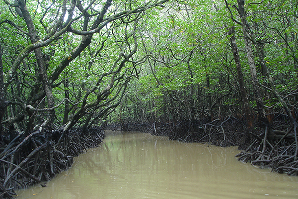
Lime Stone Cave

5 fun facts about the Limestone Caves
Mud Volcano
Diglipur and Baratang mud volcanoes started exploding and emitting mud and gas. Gas Entrapment funnels is placed at BaratangJarawa creek site by Department of Atomic Energy to monitor the Hydrocarbon levels.
Parrot Island
Rangat Island:
Amkunj Beach

Cutbert Bay Beach

Dhaninallah (Mangrove Board Walk)

Yerata Mangrove Beach Walk

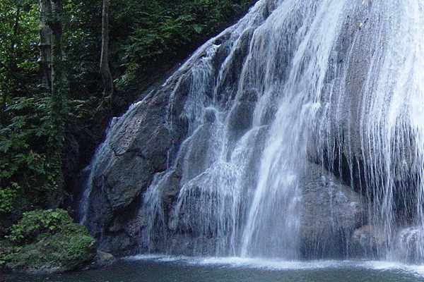
Panchavati Water Fall
Long Island:

Attractions of Long Island
World Class Lalaji bay Beach

Things/activities to do:
Word of Caution: